


Wallingford has one of the largest and most cohesive examples of early 20th-century architecture left in Seattle. Currently, there are seven locally and nationally designated landmarks in Wallingford: the Good Shepherd Center, the Wallingford Center (Interlake School), the 45th Street Clinic (Wallingford Fire and Police Station), parts of three schools—John Stanford (Latona), Lincoln, and Hamilton (primarily exterior facades and some interior spaces) – and Gas Works Park. These historic places are reminders of our past and contribute to the sense of place and identity in Wallingford for those who live and work here.
With that in mind, we decided to seek a National Register Historic District designation for its capacity to increase pride in the neighborhood, illuminate the stories of those who shaped its history, raise awareness of the importance of building and neighborhood design features, contribute to the maintenance of historic places, and attract people interested in a historic sense of place – all of this adding to the vibrancy and livability of Wallingford. For more information on the National Register of Historic Places and the listing process, visit our National Register Historic District Process webpage.

District Description
Wallingford is included within the ancestral land of the Coast Salish peoples, in particular the dxʷdəwʔabš, the Duwamish Tribe. The neighborhood is located within the city of Seattle, north of downtown and Lake Union, west of the University of Washington, and south of Green Lake. The historic district resides within the northcentral portion of the Wallingford neighborhood. N and NE 50th Street bound the historic district’s north edge, with 5th Avenue NE as the east edge along Interstate 5. The south edge is the back (north) side of commercial development along N and NE 45th Street. Interlake Avenue N (a former streetcar line route) marks the west edge of the historic district, behind (one block east of) the commercial development along Stone Way N. Adjacent neighborhoods consist of the University District to the east, Fremont and Phinney Ridge to the west, and Green Lake to the north.
The historic district encompasses the single- and multiple-family residential area and associated religious buildings that were historically served by a series of streetcar lines and enclosed by commercial development and arterial roads. The neighborhood setting consists of residential streets with concrete curbs, planting strips, and concrete sidewalks. Some residential parcels rise above street level and feature a retaining wall or a sloped grade that transitions to the sidewalk. Curb cuts and driveways provide access to garages at the front and back of parcels.

Street trees within the planting strips are a characteristic visual feature within the historic district that contributes to the spatial character of the residential setting. Substantial tree canopies are evident in 1929 historic aerials supporting the early role of street trees as a visual feature within the historic district. There is not a specific genus characteristic of the historic district, nor was a comprehensive planting effort by developers or residents identified.
Building Forms & Styles
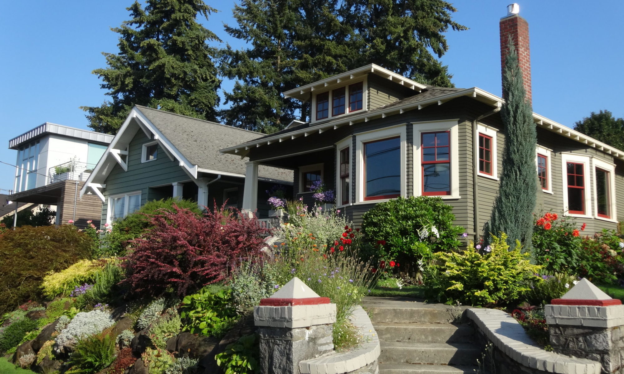
Single- and multiple-family residential buildings comprise a defining characteristic of the historic district reflecting architectural styles and kit houses popular in the Pacific Northwest during the first decades of the 20th century. The building forms, styles, and associated garages convey the pattern of development and density associated with a period of intense growth in Seattle.
Single-Family
Single-family homes in the district are typically modest in size, with nearly half being one-and-a-half stories with first-floor plans generally ranging from 900 to 1200 square feet. They predominantly feature wood framing, windows, siding, trim, and porch and stoop elements. Brick and stucco are less common and are mostly seen on chimneys. Later alterations introduced materials like aluminum, asbestos, vinyl, and cement fiberboard.
Popular single-family house forms within the historic district include the American Foursquare and bungalow because they were more affordable and efficient to build. These forms relate to prevailing styles during the period of significance (1901-1941) as well as national and city-wide housing trends. They were built to be affordable, opening home ownership to a wider segment of the population, and range in style from Craftsman and Colonial Revival to Mission Revival, with even Tudor Revival examples.


Multiple Family
Multiple-family buildings within the historic district are generally located behind (north) of the commercial core along N and NE 45th Street with recent multiple-family buildings extending along Interlake Avenue N. Building forms include low-rise apartment blocks, courtyard apartments, fourplexes, and a mixed-use commercial building.
The five low-rise apartment blocks within the historic district are two to three stories tall and occur near the main commercial arterial along N and NE 45th Street. These buildings reflect a moderate to high level of investment and were a popular multiple-family building form prior to World War II.
The courtyard-type apartment within the historic district does not have interior corridors but rather consists of two 1.5-story buildings arranged around a courtyard. Like the low-rise apartment blocks, building materials include wood framing with brick veneer with some stucco cladding, wood windows, and wood stoop elements.
The single duplex (flat) building within the historic district is two stories with separate entrances for each of the two-story single-family living units. The building exhibits the same physical features and spatial placement (setback, lot placement) as single-family dwellings within the historic district.


Styles
The application and often interpretation by contractors/builders of architectural styles convey prevailing national and city-wide trends at the time of construction, in addition to adaptations to the socio-economic conditions of building owners and the targeted middle-income homebuyer.
Buildings built within the period of significance for the historic district reflect the
characteristics of the Late 19th and 20th Century Revivals (Colonial, Classical, and Tudor Revivals and Tudor Composites), and the Late 19th and Early 20th Century American Movement (Craftsman) styles. These comprise the major styles defining the overall architectural character of the neighborhood based on the volume of their use. Other styles can be found in the historic district, including Collegiate Gothic, Queen Anne – Free Classic, Neo-Classical, and Prairie but were used on just a few buildings.
Not all buildings in the district have an easily identifiable style. Some may exhibit influences from one or more styles, support a specific function rather than a specific style, or were not designed with a particular style. Houses identified as having no style may also have been so significantly altered that cladding, window, and/or plan changes have obscured or removed original stylistic elements.


Period of Significance
The National Register of Historic Places requires the historical significance of each nominated building, structure, object, site, or district to align with a specific chronological period—the so-called ‘period of significance.’ While a historic place can have multiple such periods, they must be clearly defined by year. For the Wallingford-Meridian Streetcar Historic District, the period of significance began in 1901, the construction date of the oldest extant property in its original location within the district (1603 N 48th Street) as well as the inauguration of streetcar service in the area, and ended in 1941, the last year streetcars were in operation within the district. Streetcar lines accessing the district began switching to motorized buses and trackless trolleys beginning in 1937. The transition was completed in Wallingford in 1941 and throughout the rest of Seattle by 1944.

Historical Background
The historic district is a sub-area located within Seattle’s Wallingford neighborhood. The larger neighborhood is located on a hill overlooking the north shores of Lake Union and is roughly bounded by Interstate 5 to the east, Lake Union to the south, Stone Way N and Aurora Avenue N to the west, and N and NE 55th and 56th streets to the north. Wallingford was largely shaped by transportation connections due in part to its location between key early communities on the north side of Seattle—Ballard to the west and the University of Washington to the east—as well as its close proximity to north-south routes connecting downtown Seattle with cities, and later its other suburbs to the north.
The area that would become Wallingford was largely wooded until the late 19th century when initial development began primarily along the northern shores of Lake Union. The lake’s waterfront was cleared of timber by 1887, with many of the hills further north cleared by 1890. Non-industrial development (e.g., residences and commercial buildings) extended north from the lake but still within close proximity to the shoreline. Soon several small communities, such as Edgewater and Latona, emerged along the lake’s northern shores, particularly after the Seattle, Lake Shore & Eastern Railroad connected the lake to communities to the west and downtown via a trestle bridge in 1887. A large area north of the city, including what would become Wallingford, was incorporated within the City of Seattle in 1891. This annexation initiated a significant amount of platting activity between Lake Union and Green Lake although development did not immediately follow.
Platting
The plats in the slideshow below establish the distinct, underlying organizational framework for the historic district’s roads, blocks, and lots. These plats, located at the then north edge of the city, benefited from proximity to the streetcar line along Interlake Avenue N at the west edge of the historic district, along with the Meridian Line a half block south of the district along N and NE 45th Street, as well as proximity to places of employment. Their distinguishing characteristics reflect the multiple development influences shaping the spatial character of the historic district and the transitional role of the 1891 Baltimore Addition between the west and east platting patterns. All utilize a grid layout. Collectively they convey shifts in density through lot sizes and a change in circulation patterns to connect with neighborhood arterials to support the use of automobiles through changes in block orientation (north-south versus east-west) and the use of rounded block ends at arterial connections.
Established from 1888 to 1922, these eight plats represent waves of development optimism, associated first with the anticipated annexation of land between Lake Union and Green Lake and later with the development of the streetcar system and the influence of the nearby University of Washington campus. Plat filers include a range of property owners, including single or husband-wife landowners and real estate development corporations.

Porterfield’s Addition, platted in 1888 by Anderson Bertrand and Company. T. J. and Elizabeth E. 
Lake Union 2nd Addition, platted in 1889 by Elisha Peyre (E. P.) and Sarah T. Ferry. 
Baltimore Addition, platted in 1891 by attorney M. L. Baer, William S. Baer, Charles D. Baer, and attorney Frank Burns, Jr., all of Seattle, as well as James F. and Katherine P. McCabe of Baltimore, Maryland. 
University Hill Tracts, platted in 1905 by the University Investment Co., with Charles M. Best and Norman J.Buren, president and secretary of the corporation, respectively. 
University Hill Tracts 2nd Addition, platted in 1906 by the University Investment Co., with Charles M. Best and Norman J. Buren, president and secretary of the corporation, respectively. 
Daniels University Grove Addition, platted in 1907 by Leonard and Annie S. Daniels, fee simple owners of the land. Leonard worked in real estate. 
Smiths University Addition, platted in 1908 by Ira Bronson with the Title Trust Company, with C. S. Wiley Vice President, L. I. Gregory, secretary. 
Hope Addition, platted in 1922 by The Good Shepherd of Seattle, with Sister M. Emiliana and Sister M. Helen, President and Secretary of the corporation.
Streetcar line development in and through the area following early plats, stimulated additional platting and the actual residential and commercial development within the plats. Real estate prices also increased with streetcar access. Development in the early 1900s only increased as the University of Washington campus to the east of Wallingford was selected as the location for a world’s fair in 1909, the Alaska-Yukon-Pacific Exposition. The streetcar line that ran along NE 40th Street, south of the district, provided direct access to the fair and increased the number of residents and visitors passing through Wallingford on their way to the fair.
Industrial development along the northern shores of Lake Union also pushed residential development farther north as the Seattle Gas Light Company established its Lake Union facility in 1906, and a canal was dredged connecting Lake Washington, Lake Union, and Puget Sound beginning in 1911. During the 1910s, as the full channel was opened for ship traffic in 1917, reshaping development along the neighborhood’s south edge, residential development in the historic district reached peak levels. The opening of the canal transformed Lake Union into a boatbuilding and marine industry center. Some of those who lived in Wallingford and the historic district worked in these lake-based industries, according to the census data.

By the end of 1909, the Seattle Times reported that nearly 300 homes had been erected in the Wallingford Hill district, and by 1925 it was estimated that more than 50,000 people lived in the district. Seattle’s population boomed in the 1920s, and residential construction responded to the volume of construction. During that time Wallingford experienced a significant effort to infill its plats. Initially, there were no apartment zones in the district and it remained single-family for the most part. A push for apartment construction in the late 1920s provided greater density to the growing neighborhood. Many three- to four-story apartment blocks were constructed near streetcar lines. Commercial construction also fleshed out key commercial corridors in the neighborhood, including N and NE 45th Street, Stone Way N, and the corner of N 40th Street and Wallingford Avenue N, a key transfer point, just south of the historic district, between the Wallingford and Meridian streetcar lines.
Why “Wallingford”?
The name “Wallingford Hill” for the area began to appear in real estate advertisements in The Seattle Times and The Seattle Post-Intelligencer by 1908 as the Wallingford Avenue streetcar line was complete. By 1912, the Wallingford name for the neighborhood gained traction as it was used to brand two area churches: Wallingford Church (1414 N 42nd Street) and Wallingford Hill Baptist Mission (1929 N 45th Street).
Prior to this point, “Wallingford” only appeared in city directories as a surname or a street address. In 1913, a newly constructed joint fire and police station at the southwest corner of N 45th Street and Densmore Avenue N was named Wallingford Fire and Police Station (NRHP listed in 1983). The Wallingford name most likely came from John Wallingford, Jr., who was among the early developers to purchase one of the large tracts of land north of Lake Union in 1888 and also served two times on the Seattle City Council.
Periods of Development
Development in the district can largely be divided into four periods: 1901-1941, 1942-1956, 1957- 1985, and 1986-present. The period between 1901 and 1941 is the district’s period of significance and represents the district’s initial construction and establishment as a streetcar suburb in Seattle. The 1942-1956 period had limited development but reflected key transportation changes affecting the neighborhood and the impacts of the automobile. Between 1957 and 1985, the Wallingford neighborhood’s population decreased—due to smaller family sizes, migration of young families to Seattle exurbs, the Boeing Bust, which impacted the economy of the entire region, and the closure of the Lake Union gas plant in 1956, which resulted in the shuttering and reorganization of neighborhood schools. After significant rehabilitation efforts to key institutions in the neighborhood and changing attitudes toward urban living, the population decline was reversed, and today Wallingford continues as a thriving residential area in Seattle.
Streetcar & Suburban Development, 1901-1941
The time between 1901-1941 reflects the first intensive wave of development in the district, which built off the extensive platting that occurred in the Wallingford neighborhood before the turn of the century. The establishment and construction of neighborhood schools and transportation routes, and the 1909 World’s Fair—the Alaska-Yukon-Pacific Exposition (AYPE) hosted at the University of Washington campus to the east, were key contributors to the district’s growth. The historic district also reflects a later wave of streetcar suburban development in Seattle, aligning with the consolidation of many streetcar lines under the Seattle Electric Company and the expansion of municipal utilities.
Although much of the Wallingford neighborhood was platted between the 1880s and 1890s, the area initially remained sparsely developed farther north from the shores of Lake Union. By 1901, the Green Lake streetcar line extended north from downtown and Lake Union and looped around Green Lake. This line jogged to the east along N 45th Street to run north along Interlake Avenue N, the historic district’s west edge, and its proximity was a selling point for lots for sale in the Lake Union 2nd Addition. According to a 1905 Baist’s Real Estate atlas of the historic district area, there were only about 72 existing buildings, as much of the development at the turn of the century was still predominantly located along the northern shores of Lake Union and close to the University of Washington campus.

However, development was anticipated, and the school district purchased several larger parcels to construct new schools. Among them was a new primary school, Interlake School, constructed in 1904 at the southeast corner of 45th and Wallingford, just a half block from the district’s southern boundary. An additional school, Latona School (1906), provided educational options farther south at 5th Avenue N and N 42nd Street. Residential construction followed, and like the schools, many early homes predominately reflected Classical Revival architecture.
Between 1905 and 1910, the number of buildings within the district more than doubled. Lots within the Daniels’ University Grove plat (1907) advertised as fronting the newly completed N and NE 45th Street streetcar line, within walking distance of the university, and within close proximity to multiple schools. These new plats, plus the establishment of neighborhood amenities and improvements such as the arrival of the streetcar lines, spurred residential construction in the neighborhood.
In addition to the residences constructed, numerous social and religious institutions arrived in the neighborhood. These included the Home of the Good Shepherd who in 1907 established a large 6-block campus between Meridian Avenue N and Sunnyside Avenue N and N 47th Street and N 50th Street The Home of the Good Shepherd was operated by sisters of the Good Shepherd Order and provided shelter, education, and guidance to young girls. They also operated a commercial laundry to generate revenue. St. Benedict Roman Catholic Parish was founded in the area in 1906 and began meeting in the district in 1907 in a basement until their building at the northwest corner of N 49th Street and Wallingford Avenue N was completed. Later they developed a school. Lincoln High School was also a boon to the neighborhood when it opened in 1907, located at N 44th Street and Interlake Avenue N. The Elim Swedish Baptist Church was established in the area in 1903, and they constructed a new church building in the nominated area dedicated in 1913 at 2410 N 46th Street. Like many other congregations in Wallingford, this one was established by a group of immigrants, in this case, from Sweden.

The selection of Seattle for the 1909 World’s Fair set in motion citywide improvements in preparation. Wallingford received many of these improvements, including grading, curbing, and sidewalks for several avenues between 1907 and 1909. The completion of streetcar lines connecting the district with other neighborhoods also spurred development in order to supplement the existing Green Lake Line along Interlake Avenue N. Additional streetcar line tracks were laid east along N and NE 45th Street from Meridian Avenue N to the University District in 1907 and by 1908 connected with the Wallingford Avenue Line along Wallingford Avenue N. The Wallingford Avenue Line of the Seattle Electric Company also began service in January 1907, which was extended in 1909 to the AYPE grounds, but was cut back after the fair. The Meridian Line with service through Wallingford began in July 1908 and was extended in 1909 to run north up to NE 65th Street.
By 1910, there were just over 200 residences within the district, and the Craftsman style was firmly established as the dominant architectural style for the rapidly growing neighborhood. The Wallingford Commercial Club had been founded to promote Wallingford businesses, particularly along its emerging commercial corridor on N and NE 45th Street. Over the next decade, the district grew significantly, both in population and the number of residential buildings (472).
In the midst of the historic district’s growth, the City Council adopted Ordinance 45382 (i.e., the zoning ordinance) in 1923, which divided the city into districts and, rather than just focusing on building materials like in previous ordinances, began regulating the use, heights, and size of buildings, and restricting the location of trades and industries. More than 75 percent of the historic district was constructed in or before 1923 when Ordinance 45382 was adopted. The land within the historic district was classified as within a First Residence zone except for the Home of the Good Shepherd, which was classified as a Second Residence zone.
During this time, the Wallingford Commercial Club began to petition the Zoning Commission to rezone part of the neighborhood to allow for additional apartment home construction in blocks adjacent to N and NE 45th Street to continue to grow the community. Several apartment buildings within the historic district adjacent to N 45th Street, as well as the courtyard apartments along N 48th Street, were built between 1925 and 1929 and contributed to this effort to support increased density adjacent to the commercial core. The rise of the automobile was already evident in the garages constructed at both new single- and multi-family residences.
By 1930, most of the available lots in the historic district had been built out. Streetlights lit portions of the neighborhood and it was a thriving residential area in the city. The greater Wallingford neighborhood, including the historic district, had a population estimated by one account to be nearly 50,000. Construction of the Aurora Bridge and associated highway along the west edge of Wallingford by 1933 made the neighborhood more physically accessible. However, it spurred a shift in transportation away from the streetcars that had shaped the early development of both Wallingford and the historic district. Highway access to the neighborhood, along with the steady increase in personal automobile ownership and use, altered the neighborhood’s landscape and led to the decline and ultimate cessation of the streetcar traffic to and through the district and neighborhood.
Conversations about transforming public transportation gained traction in the 1930s and trackless trolley and bus routes began to supplant the older street car lines. The Green Lake Line was replaced by buses in 1937, followed by the Wallingford Line in 1940, and the Meridian Line in 1941. The transition to electric or motorized buses was completed in 1941 when the last streetcar ran in the city. The city was able to apply to the federal government for financial assistance, via a $10 million loan from the Reconstruction Finance Corporation, to implement their revised transportation program. With financial assistance from the federal government, the City removed streetcar tracks throughout Seattle and repaved streets between 1943 and 1944.
From Streetcar to Automobile Suburb, 1942-1955
In the mid-1930s, development around and within the Wallingford-Meridian Streetcar Historic District reflected significant changes. The once ubiquitous streetcar lines were replaced by bus lines, and cars became predominant. Commercial development along N and NE 45th Street emphasized parking lots. Residences featured street-facing garages instead of garages set toward the back of the lots.
Amidst these transportation-related shifts, World War II had implications on the home front, including a housing shortage due to the city’s population surge in support of the local defense industry. Between 1940 and 1950, Seattle’s population increased by 27 percent, reaching over 467,500.
The automobile significantly shaped the commercial core along the district’s south edge and the surrounding Wallingford neighborhood in the post-WWII era. Businesses shifted their focus to auto-oriented shopping and traffic.

Notable examples include Wald’s Foodland (later renamed Food Giant), which opened at Wallingford Avenue N and N 45th Street in 1950. Later, the store’s main elevation was set back from the street to accommodate a parking lot, and a large rooftop sign facilitated easy advertising to passing cars.
The status of N and NE 45th Street as an auto thoroughfare was solidified with the construction of Dick’s Drive-in, the first stand in an expanding local chain of fast-food restaurants, in 1954.
Wallingford at the Turning Point, 1956-1985
Land use, transportation, and population changes in the surrounding Wallingford and Seattle neighborhoods impacted the historic district in the 1950s, 60s, and 70s. Furthermore, the 1971 financial losses of Boeing, a prime industry in Seattle, sent a ripple effect of population and income decline through the city, neighborhood, and historic district. Land use changes include the City Council’s adoption of a new city land use ordinance (Ordinance 86300) in 1957, repealing the 1923 ordinance. In addition to regulating use, height, size, location, and parking for buildings and structures, the new zoning ordinance also emphasized the importance of stable property values, stating, “The economic stability of land use areas and conservation of building values are promoted and protected thereby.” This reinforced the effects of ongoing exclusionary lending practices and put into policy the exclusionary priority given to single-family housing. Greater flexibility in property use was allowed within the 1923 Zoning Ordinance, but it was severely limited by the 1957 Zoning Ordinance and associated Comprehensive Plan.
Continued transportation improvements affected the historic district and surrounding development. Plans for a Seattle Freeway (Interstate 5) began in 1951, with federal approval and funding occurring in October 1957. The right-of-way for the new freeway required the Washington State Highway Department to acquire a two-block swath of properties between 5th Avenue N and 7th Avenue N, abutting the eastern boundary of the historic district. All the properties in these two blocks were demolished or sold at auction; the sold properties were either salvaged or moved to new sites. All properties in the path of the freeway were deemed nuisances, regardless of condition.
The entire length of Interstate 5 through Seattle opened in 1965. Although this path abuts rather than bisects the district, the concrete highway restricted Wallingford’s access to the University District, which had originally been a selling feature in the neighborhood’s infancy. The ease of access to freeways, with Aurora Avenue/Highway 99 to the west and Interstate 5 to the east, made shopping farther outside of the neighborhood easier for residents.
Residential construction remained minimal in the historic district during the post-war years, with a handful of apartment buildings being constructed, like the Mari Don at 1621 N 47th Street (1966). As the population declined in the area, the value of Wallingford’s proximity to the University of Washington reemerged. As enrollment boomed at the university, first with veterans utilizing the benefits from the G.I. Bill and then their children, the campus faced a severe housing shortage. Developers and property managers looked to surrounding neighborhoods to house students. Many single-family houses in Wallingford’s neighborhood were converted to duplexes. However, property owners within the neighborhood pushed back against this effort, seeking to retain the single-family land use, and complained to the City. Their efforts resulted in a prohibition of new duplexes in much of the neighborhood.

In the 1970s, several factors transformed the Wallingford-Meridian Streetcar Historic District’s character and threatened its stability. Notably, the closure of the Seattle Gas & Electric Light Company plant—a significant industry south of the district—occurred in 1956. Although this closure eliminated air pollution that had affected the neighborhood south of N 40th St, the contaminated site struggled with redevelopment and served as a parking lot for years. Other closures within the district and surrounding neighborhood included the Interlake School (converted from an elementary school in 1972), the Home of the Good Shepherd (closed in 1973), and Lincoln High School (closed in 1981). The Home of the Good Shepherd narrowly avoided becoming a shopping center due to neighborhood activism, leading the City of Seattle to purchase the property in 1976. Preservation and revitalization efforts eventually turned potential losses into gains. For instance, the Home of the Good Shepherd site west of the building became Meridian Playground, while the building itself transformed into a multi-purpose community center. Additionally, the former gas plant on Lake Union underwent extensive remediation and emerged as Gas Works Park, drawing visitors to the greater Wallingford neighborhood. The Interlake School, now known as Wallingford Center, was leased to a developer in 1982 and converted into a mixed-use building housing retail, restaurant, and residential spaces.
In the 1990s, city planning introduced the urban village concept, and over 25 blocks of the nominated historic district were designated as a Residential Urban Village (west of Sunnyside Avenue N, excluding the Good Shepherd Center, Meridian Playground, and the lots east of it). This designation identified this area of Wallingford as able to accommodate additional growth with increased density. The urban village strategy intended to accommodate increases in population by concentrating density in various identified neighborhoods throughout the city. With this, the residential trends are slowly beginning to reverse. High-density residential construction has increased within the last two decades along the south and west edges of the historic district, aligning with the urban village designation and the increased density pressure near the district’s commercial corridors.
Social History
Part of the process to prepare the historic district nomination involved understanding the patterns of development, what shaped them, who lived in the area, and how all of this is communicated through the area’s existing built environment. Census records, used in conjunction with Seattle Polk city directories and Baist Real Estate, Sanborn Fire Insurance, plat, zoning, and redlining maps, proved a key tool in understanding this context. Census enumeration cards were collected from 1910, 1920, 1930, and 1940. With the help of volunteers, this hand-written data was transcribed into spreadsheets to organize extensive data about the people who lived in the area, allowing us to not only see the data but how it evolved over the district’s period of significance (1901-1941).

In 1910, when the U.S. Federal Census was taken, there were just over 200 residences within the district. Of these 203 residences, 23 percent were rentals while 72 percent were owner-occupied (5 percent did not have information). The district’s residents were largely white and U.S. or European-born. The 1910 census lists the broad range of occupations held by residents within the district. Commerce was the main area of employment and included office workers, salespeople, professionals (accountants, architects, engineers), and specialty business employees (auto garages, bakers, tailors, and butchers). Industry in 1910 consisted mostly of tradespeople (painters, carpenters, brick layers) as well as people working in extraction (logging or mining), maritime-related jobs, and manufacturing. Other occupational fields were represented within the district, including government (fire/postal/police workers), education (teachers), religious, funerary, defense, healthcare, recreation and culture, and subsistence workers. One outstanding example is Thomas Foster, who settled into a new home on Thackeray Pl NE when he relocated to Seattle in 1908 to become chief of the Northwest Secret Service Office.

Single-family house conversions to multiple-family dwellings both within and outside the period of significance provided an important mechanism for increasing density within the historic district. Census records indicate residential conversions within the period of significance started between 1910 and 1920, increasing households to two or more for multiple houses within the historic district. However, the renter to owner-occupied ratio of the residences in the district in 1920 remained very similar to that from 1910.
The same range of occupations was represented within the district and the neighborhood remained largely white and of Euro-American descent according to the 1920 census. Yet as a survey conducted once every ten years, there are several residents’ stories not represented in the census, such as Antonio Quiroga, who moved to Seattle in 1922 to serve as the Consul of Bolivia. He and his Argentinian wife Maria Christina Lorena de Quiroga moved into a 1913 Craftsman home on N 47th St. Their story is representative of the diverse range of immigrant stories found within the historic district.


In the midst of the nationwide Great Depression, the historic district had an over 10 percent increase in the number of rental households, from 22 percent of houses in the district occupied by renters in 1920, to 33 percent in 1930. The U.S. Government had been encouraging home ownership to middle class families for years, but it still remained out of financial reach for most urban and working-class families and individuals. Under President Franklin D. Roosevelt, the Home Owners’ Loan Corporation (HOLC) was established in 1933, which purchased mortgages at risk of foreclosure and issued new ones with longer repayment terms. To assess risk, they created color-coded maps, known as residential security maps. These maps influenced lending practices and often redlined neighborhoods with higher risk levels, including areas near industrial operations and with diverse populations. An area of southern Wallingford near the gas plant located on the shore of Lake Union was shaded red (redlined) on the maps. This area is not within and is some distance away from the historic district.

In 1934, Congress established the Federal Housing Administration (FHA) to insure bank mortgages. The FHA continued discriminatory practices from the HOLC, assessing risk based on racial factors. Real estate agents and residents responded by creating racially restrictive covenants to prevent their neighborhoods from being “redlined.” Although there is no evidence that there were any formal restrictive covenants in the historic district, it is clear that de facto segregation was at play in Seattle and Wallingford. Few individuals of color resided within the boundaries of the district and much of the Wallingford area received a “B” or “still desirable” ranking on the 1936 residential security map.
The number of renters in the historic district began rising during the years following the Great Depression until 1940 when 40 percent of the houses within the district were renter-occupied. Another trend seen in the historic district at this time was the rise in female head of households. None were indicated on the 1910 census, however by 1940 there were four divorced women, four single women, 19 widows, and one set of partners (defined as two or more persons, not related by blood or marriage, sharing a common dwelling unit). Stories from within the historic district highlighting independent women of Wallingford include that of Margaret Denton O’Hare, an Irish immigrant with her story of strength and resilience, Mathilda Clarkson, an immigrant and widowed mother of four, and Lady Willie Forbus, a legal pioneer and lifelong advocate for women, children, and the working class.
Builders
Several architects, builders, and real estate developers not only developed property in the district but also lived in the greater Wallingford neighborhood, including W.J. Landon, Harry B. McKnight, Henry Nelson, and Jud Yoho.
The historic district still reflects the professional overlap resulting from these developers living and working in Wallingford together. The Landon Real Estate Company, incorporated by W.J. (Jack) and Verah Landon in 1927, developed three 19-unit apartment blocks within the historic district along N 46th Street and Burke Avenue N. The Landons hired local architect Harry B. McKnight to design one of these apartment buildings, the Landon Arms (1928). McKnight, who was 28 years old at the time, had immigrated from Ireland as a boy and was a World War I veteran. His later projects include the Bungalow Court Apartments (1930) on N 48th Street, the Galer Crest Apartments in Queen Anne, and the Butter Krisp Baking Company building near the Mt. Baker neighborhood.

Other neighborhood developers were merchant builders, like Henry Nelson, whose real estate office was at 2202 N 45th Street, where a ghost sign still advertises his firm today. Nelson immigrated from Denmark with his wife Mary in 1885. They resided for many years in south Wallingford at 3645 Densmore Ave N. Nelson built and sold homes throughout Seattle in the 1910s and 1920s, including the modest house at 4508 Bagley Ave N.
Evaluating Significance & Integrity
Primary and Secondary Buildings
Construction of 92 percent of the extant primary (not including garages) buildings within the historic district occurred within the period of significance for the historic district, 1901-1941. Subsequent infill and replacement construction amounts to 8 percent of extant primary buildings.
Secondary detached buildings that are substantial in size and scale, predominately garages, were evaluated as part of each property since they are functionally related. Attached garages were evaluated as part of the house and not treated as a separate detached structure.

Contributing vs Noncontributing Resources
Historic contributing buildings are those built within the period of significance that retain integrity and convey the historical associations for which the historic district is historically significant.
Historic noncontributing are those buildings that are 50 years old or older but have experienced substantial alterations to their exterior visual character or were built outside of the period of significance.
Non-historic, noncontributing are those buildings that are less than 50 years of age and built after the period of significance.
In assessing buildings, key elements conveying integrity of design, materials, and workmanship were assessed from the public right of way since the visual character evident when walking or driving along the streets is the measure of the integrity of feeling within the historic district. The primary character-defining features evaluated on each building were windows, cladding (including trim and detailing), and plan (encompassing the full building envelope) based on what was visible from the public right of way.
Garages were identified as contributing if they retained their plan, garage door opening (the door could have been replaced), and some original cladding materials. Flat roof garages with added railings for rooftop decks were considered contributing as the essential form and function remained legible. However, the age and integrity of the primary building determined each property’s overall contributing or noncontributing status.
Historic Residential Suburbs Multiple Property Documentation
The Wallingford-Meridian Streetcar Historic District is nominated under the “Historic Residential Suburbs” Multiple Property Documentation (MPD). It aligns with the MPD’s definition of a historic residential suburb: a geographic area outside the central city, historically connected to the city via transportation modes, subdivided primarily for residential use, and possessing a significant concentration of dwellings, roads, utilities, and community facilities. This district represents a cohesive historic neighborhood or suburb, achieved through historical events and associations. Located along streetcar lines, it comprises contiguous residential subdivisions historically interrelated by design and planning. During Seattle’s population boom, streetcar lines facilitated reasonably priced housing, resulting in a significant concentration of Craftsman bungalows that creates a cohesive visual identity within the neighborhood and reflects the intense development that occurred in just a few decades.
Statement of Significance
The period of significance begins in 1901, the construction date of the oldest extant property in its original location within the district (1603 N 48th Street, built ca. 1901) as well as the inauguration of streetcar service in the area, and ends in 1941, the last year streetcars were in operation within the district. Streetcar lines accessing the district began switching to motorized buses and trackless trolleys beginning in 1937. The transition was completed in Wallingford in 1941 and throughout the rest of the city by 1944. The district meets the registration requirements as set forth in the Historic Residential Suburbs in the United States, 1830-1960 MPD, and was nominated for its historic significance under National Register Criterion A, Community Planning and Development, and Criterion C, Architecture.

The Wallingford-Meridian Streetcar Historic District is historically significant under Criterion A as an intact “Streetcar Suburb,” representing the broad patterns of residential development and growth in Seattle during the early 20th century. The development was spurred by a population boom in the city and largely developed within a short 20-year time span. This formed an interrelated, cohesive design. When initially developed, the neighborhood was located on affordable land outside the city center and could be accessed through the use of streetcar lines. The clustering of apartment buildings on blocks closest to transit lines and the neighborhood business district reflects this subtype of suburb. Such conditions created a middle-class neighborhood of blue-collar workers who supported a variety of business ventures across the city.
The historic district is also significant under Criterion C as a collection of properties that embody the distinctive characteristics of their type and period of construction. The designated area contains a concentration of architectural styles popular in the Pacific Northwest during the first decades of the twentieth century. Notable is the wide range of interpretations of the Craftsman style, constructed by multiple builders. The simplicity and artistry of these buildings harmonized into an affordable house design that provided style, convenience, and simplicity, which was within the reach of many middle-income families at the turn of the 20th century.

Integrity
The district retains its historic integrity achieved during the period of significance (1901-1941); alterations to the neighborhood since the period of significance have not substantially diminished the district’s ability to convey its significance. Its integrity is conveyed through the district’s location, design, setting, materials, workmanship, feeling, and association. Move through the slideshow below to learn how each measure of integrity has been retained within the Wallingford-Meridian Streetcar Historic District.


Discover more about the history and significance of the Wallingford-Meridian Streetcar Historic District by reviewing part or all of the nomination below:
- District description & property inventory – pgs. 1-48
- Property descriptions — pgs. 49-277
- History & significance — pgs. 278-296
- Maps & photographs — pgs. 297-end
- Complete nomination (14 MB)
The Wallingford-Meridian Streetcar Historic District project and the creation of this webpage were sponsored, in part, by generous grants from 4Culture.